
Hans Monderman was a Dutch traffic engineer "renowned for his innovative "shared space" plans emphasizing human interaction and negotiation over blind obedience to traffic signals." [ref: http://en.wikipedia.org/wiki/Hans_Monderman]
He designed a modified roundabout called a "squareabout" which had the unusual feature of having no signage to indicate priority (although it did incorporate some road markings). I was somewhat skeptical of his unconventional ideas, despite they're gaining worldwide attention, but I've concluded that they combine both mobility and safety for all road users in a unique way at the place normally fraught with most danger for pedestrians and bicyclists.
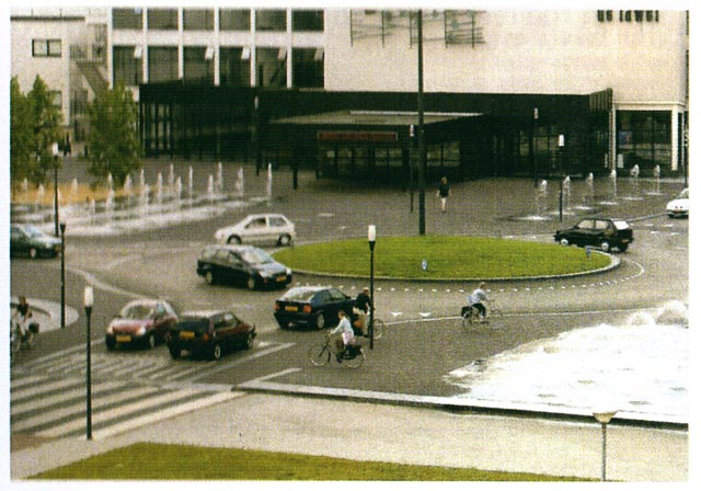
Below are before and after views of the busiest intersection in the Dutch town of Drachten, with over 44,000 inhabitants [according to a Google search: ref. http://population.mongabay.com/population/netherlands/2756644/drachten]
You will note that the original wide intersection was already somewhat pedestrian-friendly, having a center refuge and a wide well-defined pedestrian crossing more typical of European treatments as compared to those in the U.S. The part of the road with a red painted surface is a bike lane. Overall it is fairly conventional.
The transformation after Monderman's treatment is stunning, as shown below right. You can see vestiges of the original, such as the curbing curving around near top left, but otherwise, apart from the buildings, it is unrecognizable.


Monderman has made this space much more pedestrian-friendly by greatly expanding the already wide sidewalks in an ill-defined way, confining motorists to a single lane in each direction. Despite the confinement, motor vehicles are now free-moving and drivers are subject to dynamic, as opposed to static, traffic control at the intersection, which potentially makes for increased efficiency of movement. That is borne out by before and after studies which also show it to be much safer for all users than a conventional treatment. The openness and green center circle also enhance this space visually.
 I originally lived in England where traffic control at major intersections in many towns follows the American pattern of stop lights. However, where space permits, roundabouts are often employed and have the advantage of dynamic traffic control which, in such a densely populated country, is helpful at keeping motor vehicles moving through the intersection.
However, my experience of roundabouts in England is that they aren't particularly bicycle-friendly. The one shown above-left is typical of several in Harlow, England, where I formerly lived. It is situated on the eastern edge of town on the A11, the main north-south arterial road going from London to Cambridge. (Please see below for more discussion of this particular roundabout. Click image repeatedly to enlarge.)
Motor traffic in the roundabout is often relatively fast-moving and motorists already in the roundabout have priority over those wishing to enter. A cyclist lacks the acceleration of a motor vehicle, making it difficult to take advantage of a gap in traffic in a busy roundabout. If the roundabout has two lanes, as shown here, that can add further complexity for the cyclist trying to navigate through it safely.
Pedestrians also have to be wary, although most roads near where they enter a roundabout will have a traffic island or "refuge" in the middle of the lane, facilitating pedestrian movement, because crossing to the island only requires looking in one direction for approaching traffic.
Returning to the Monderman squareabout in Drachten, some traffic engineers, evidently from Britain, who toured the area with him, subsequently posted some interesting video on YouTube. I particularly recommend viewing the following from which still images have been captured and included below:
Monderman (3of10) – Drachten Roundabout Traffic
A misty day at the "squareabout" in Drachten. Motorists approach and traverse the intersection slowly and cautiously, and are evidently prepared to stop at a moments notice to yield.
 Fig. 3-10a
Time = 9 sec.
That works to the advantage of a female bicyclist who appears out of the mist 9 seconds into the clip while giving a semi-left turn signal as she approaches a road entering the intersection to her right. She is riding between the roundabout on her left and a pedestrian crossing on her right with a motorist just about to ease forward to the edge of the roundabout.
 Fig. 3-10b
Time = 13 sec.
Showing the cyclist part-way across while passing just behind the motorist, who is still easing forward.

Fig. 3-10c (at left) Time = 18 sec. The cyclist continues on in the "squareabout." Notice it has a different surface texture to the road and also is slightly elevated, as shown clearly above.
 Fig. 3-10d (below right) Time = 19 sec. The cyclist really meant that she was turning left when she gave that hand signal 10 seconds earlier!
It's still a surprise, from the vantage point of the videographer (and viewer), when the cyclist makes a sharp left turn onto a shallow ramped crossing shortly afterwards in front of a stopped motorist in a blue car to her right, and with an approaching motorist on her left. It seems reckless but is evidently very safe.
Monderman (9of10) – Drachten Intersection
Monderman driving towards the Drachten squareabout (Fig. 9-10a), then pausing to enter while looking to his left (Fig. 9-10b), and finally as he's about to exit, waiting for a woman with her dog crossing his path, while using a slightly raised convex pedestrian crossing (Fig. 9-10c). She seems not to be paying attention and is quite unhurried. Nobody seems irritated by the casual attitude displayed. It's all quite civilized.

Fig. 9-10a

Fig. 9-10b
 Fig. 9-10c
"The Laweiplein – Evaluation of the reconstruction into a square with roundabout"
Traffic safety studies on this intersection were conducted in the period 1994 through 2002 before its reconstruction and again in 2004 and 2005. Other detailed information is included in a booklet published in January 2007: "The Laweiplein – Evaluation of the reconstruction into a square with roundabout" from which the following data are taken.

The image below was obtained via Google Earth. The yellow push pin I've added to the middle of the roundabout in the center of Monderman's "squareabout" is at latitude 53º06'11.29" N longitude 6º05'54.68" E, as indicated at the bottom of the image.

Above is Figure 1.3 from page 13 of the report – "Photo of the Loweiplein in Drachten, new design of square with roundabout, since 2001." On the far side of the roundabout is the entrance to Theatre De Lewei: its name is just visible in the top right of the photo. Note both the absence of traffic signage and the addition of numerous water features to enhance the space visually.
Table 4.1 from page 26 of the report (see below) is an analysis of traffic accidents before and after reconstruction, showing a notable improvement. Note that no data is included for the reconstruction period in 2003.

Public opinion surveys conducted in 2000 and 2005 reveal some interesting and counter-intuitive results. In the section "Public opinion of the Laweiplein" the report noted on page 28, concerning Public opinion in Drachten and the city region:
* Public perceptions of traffic safety have declined since 2000, with around 45% responding "poor" or "bad" to opinions on traffic safety compared to 30% in 2000. A significantly higher proportion of elderly people are negative about traffic safety now (47% compared to 38% before). The relationship between the increased perception of danger, and the reduction in accidents recorded, may be significant.
* Drivers and bicyclists perceptions of traffic safety have declined. Pedestrian perceptions seem to remain unchanged.
* Perceptions of personal safety have improved. Over 81% now rate this "reasonable" or "good" compared to 71% in 2000. The change is especially notable amongst pedestrians and cyclists, as well as amongst elderly people.
Among the reports conclusions on pages 30-31 are these:
* Although traffic speeds are slower, vehicles generally keep moving on the intersection resulting in reduced delays.
* Despite occasional peak hour congestion on two of the approach roads, traffic flow has improved significantly following the removal of the traffic signals.
* A substantial reduction in delays to public transport has been achieved.
* Pedestrians and bicyclists appear able to cross the intersection without significant delay, usually being waved across by drivers. This appears to reflect the reduction in the range of speeds between different modes, giving greater equality of movement.
* There has been a remarkable increase in the use of informal hand signals between users of the intersection, with bicyclists in particular indicating direction more often than usual, and greater use of indicators (turn signals) by drivers.
* Public perceptions of spatial quality and personal security have improved.
* The twin functions of the Laweiplein as both an important traffic intersection as well as a significant piece of public space for the City of Drachten appear to have been reconciled by the unconventional new configuration and the application of shared space principles.
Following are excerpts from an article by Tom Vanderbilt, "The Traffic Guru," on Hans Monderman and his Drachten town center transformation. The entire article, published in The WILSON QUARTERLY, August 13, 2008, can be found on-line by clicking here.
Traffic engineers are rather obscure characters, though their work influences our lives every day. In the last few years, however, one traffic engineer did achieve a measure of global celebrity, known, if not exactly by name, then by his ideas. His name was Hans Monderman. The idea that made Monderman, who died of cancer in January 2008 at the age of 62, most famous is that traditional traffic safety infrastructure— warning signs, traffic lights, metal railings, curbs, painted lines, speed bumps, and so on— is not only often unnecessary, but can endanger those it is meant to protect.
As I drove with Monderman through the northern Dutch province of Friesland several years ago, he repeatedly pointed out offending traffic signs. “Do you really think that no one would perceive there is a bridge over there?” he might ask, about a sign warning that a bridge was ahead. “Why explain it?” He would follow with a characteristic maxim: “When you treat people like idiots, they’ll behave like idiots.” Eventually he drove me to Makkinga, a small village at whose entrance stood a single sign. It welcomed visitors, noted a 30 kilometer-per-hour speed limit, then added: “Free of Traffic Signs.” This was Monderman humor at its finest: a traffic sign announcing the absence of traffic signs.
And Monderman certainly changed the landscape in the provincial city of Drachten, with the project that, in 2001, made his name. At the town center, in a crowded four- way intersection called the Laweiplein, Monderman removed not only the traffic lights but virtually every other traffic control. Instead of a space cluttered with poles, lights, “traffic islands,” and restrictive arrows, Monderman installed a radical kind of roundabout (a “squareabout,” in his words, because it really seemed more a town square than a traditional roundabout), marked only by a raised circle of grass in the middle, several fountains, and some very discreet indicators of the direction of traffic, which were required by law.
As I watched the intricate social ballet that occurred as cars and bikes slowed to enter the circle (pedestrians were meant to cross at crosswalks placed a bit before the intersection), Monderman performed a favorite trick. He walked, backward and with eyes closed, into the Laweiplein. The traffic made its way around him. No one honked, he wasn’t struck. Instead of a binary, mechanistic process—stop, go—the movement of traffic and pedestrians in the circle felt human and organic.
A year after the change, the results of this “extreme makeover” were striking: Not only had congestion decreased in the intersection — buses spent less time waiting to get through, for example — but there were half as many accidents, even though total car traffic was up by a third. Both drivers and, unusually, cyclists were using signals— of the electronic or hand variety— more often. They also found, in surveys, that residents, despite the measurable increase in safety, perceived the place to be more dangerous. This was music to Monderman’s ears. If they had not felt less secure, he said, he “would have changed it immediately.”
Tom Vanderbilt is the author of Traffic: Why We Drive the Way We Do (and What It Says About Us), published summer 2008 by Knopf, from which portions of the original essay are drawn. He lives in Brooklyn, New York.
Excerpt reprinted from Summer 2008 Wilson Quarterly in March 2010, with permission.
(For further reprint information, please contact Permissions, The Wilson Quarterly, One Woodrow Wilson Plaza, 1300 Pennsylvania Avenue, NW, Washington, D.C.
Phone:202/691-4200
E-mail: wq@wilsoncenter.org)
I am personally interested in seeing this innovative treatment tried in the U.S. and an ideal location, in my view, would be my own home town of Ferguson, a city of a little over 20,000 population in North St. Louis County, Missouri. This is part of a sprawling urban area with a county population of approximately one million inhabitants.
I live in a quiet subdivision just off a north-south four-lane road with a 35 mph speed limit. Less than a mile south is a major intersection at the beginning of the commercial district of downtown Ferguson. It is illustrated in the photo below obtained using Google Earth with a yellow push-pin indicating the intersection's center. Below it is the Monderman "squareabout" reproduced to the same scale.

The image below is a repeat of the Monderman "squareabout" shown above, but captured from a height roughly 100 meters above the circle so that it's to the same scale as the image above.

Actual measurements for the squareabout were kindly provided by Mr. Erik Wietzes in Holland on March 15, 2010. They are shown in the above figure after conversion from meters to feet, i.e.
Grass covered roundabout = 7.40m = 24.27 ft
Concentric broken circle = 8.00m = 26.24 ft
Outer concentric circle = 14.00m = 45.92
Hence, width of single lane around roundabout = 6.00m = 19.7 ft
The image below shows concentric circles of the above dimensions superimposed and centered on the existing Florissant/Airport-Hereford intersection.

Harlow roundabout at intersection of A11 and Southern Way
This roundabout was featured above as one relatively good for moving motor vehicles efficiently and at fairly high speed, but poor for pedestrians and cyclists. It is reproduced below with some additional details picked out.

The original Old London Road, predating Harlow New Town, became part of the new cycleway system when the new A11, shown here, was built. Below is a photo taken from the direction of the red arrow above, looking towards the roundabout. In the foreground is a speed limit sign which means "National speed limit," i.e. a speed limit of 60 mph on this road. Near the roundabout are two children on bikes who have just emerged from the cycleway and are waiting to cross.

The refuge seen in the distance in the photo above is just a road splitter and is of no help for the children crossing who must therefore look in both directions for no approaching traffic for a safe gap. The two-lane roundabout allows motorists to maintain a relatively high speed, compounding the problem for the cyclists. And on the far side of the road where the cycleway continues, there is a curb to negotiate! Could this intersection be much worse for cyclists?
References:
In addition to the references noted above I append below others providing interesting background information on Hans Monderman and how his ideas developed and came to fruition, as well as how they have since been adopted in other countries, including the US in West Palm Beach, Florida.
Roads Gone Wild, by Tom McNichol, Wired Magazine, 12 December 2004, with other contributions at http://www.walkablestreets.com/wild.htm
Towards shared space, by Ben Hamilton-Baillie, Hamilton-Baillie Associates Ltd, 94 Whiteladies Road, Clifton, Bristol BS8 2QX, UK
http://www.hamilton-baillie.co.uk/_files/_publications/30-1.pdf
