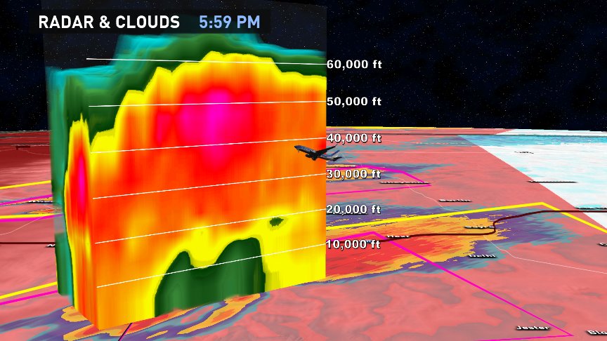
Once in a while, the atmosphere will create a large cloud. So big, even airliners designed to fly high in the stratosphere can not climb above its reaches. Typical storm clouds range from 30,000 feet to as high as 50,000 feet, if it's severe. Today in the Panhandle of Texas convective storms clouds punched 70,000 feet high as intense updrafts, moving at over 100 mph, formed due to a, "dry line", which plowed tropical Gulf moisture skyward until it was stopped by the bounds of our atmosphere itself.
If you use your imagination, you *may* be able to see the mid-level portion of this #Texas #supercell rotating with #GOES16 500-m VIS band pic.twitter.com/A6dkUZAcZK
— Dan Lindsey (@DanLindsey77) May 16, 2017
At 70,000 feet, as indicated by radar, that's some 40,000 feet higher than the border of the troposphere (where 99.9% of, "weather" happens). There's certainly no oxygen up there to sustain life. In fact, at 60,000 feet, you hit what's known as the Armstrong Limit, where even if you're sporting a pressurized mask in your fighter jet, if you're not wearing a space suit and your cockpit loses pressure, you'd pass out and die within minutes. At that altitude, your blood and tears would literally boil at room temperature. If you were a pilot, you might first notice the saliva on your tongue start to fizz in your mouth, like you were eating rock candy.
Check out the structure on these supercell, tornado-warned storms 80mi east of Amarillo, TX! 70,000ft cloud tops?! pic.twitter.com/GkK7i8A6uP
— Brooks Garner (@BrooksKHOU) May 16, 2017
These storm clouds were reaching nearly 2 miles above the Armstrong Limit, "boiling point"! This is an altitude where not only is there no air to breathe, but the sky at Noon directly above you is jet black, as you peer into the vacuum of space high above. It's the approximate altitude which only the SR-71 Blackbird and U-2 could fly. No plane without a rocket can go higher than this (at which point it becomes a space craft).
Huge 60,000-70,000ft cloud tops on the Texas Pan Handle with tornadoes and 37,000ft altitude planes are dodging them! (@flightaware) pic.twitter.com/2Wj01cVXiu
— Brooks Garner (@BrooksKHOU) May 16, 2017
So... for commercial flights this afternoon over the TX Pan Handle Panhandle (I know -- I blame auto-correct on my iPhone for that Twitter spelling faux pas), the only option was to navigate around storms. That meant awkwardly funneling into the same areas before going back to the desired latitude for to complete their cross-country routes.
-Brooks