

Holyrood Park, Edinburgh - Geowalks
Holyrood Park, Edinburgh - Geowalks
Holyrood Park, Edinburgh - Geowalks

You also want an ePaper? Increase the reach of your titles
YUMPU automatically turns print PDFs into web optimized ePapers that Google loves.
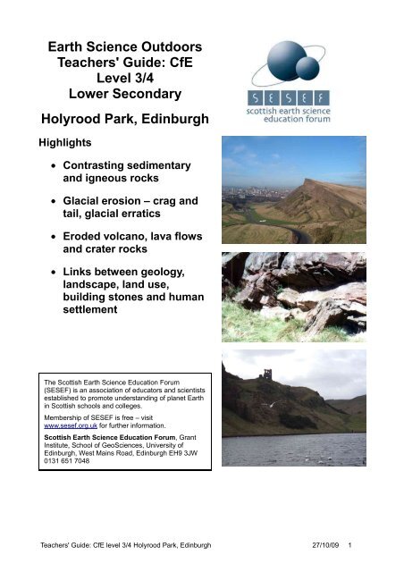
Earth Science Outdoors<br />
Teachers' Guide: CfE<br />
Level 3/4<br />
Lower Secondary<br />
<strong>Holyrood</strong> <strong>Park</strong>, <strong>Edinburgh</strong><br />
Highlights<br />
• Contrasting sedimentary<br />
and igneous rocks<br />
• Glacial erosion – crag and<br />
tail, glacial erratics<br />
• Eroded volcano, lava flows<br />
and crater rocks<br />
• Links between geology,<br />
landscape, land use,<br />
building stones and human<br />
settlement<br />
The Scottish Earth Science Education Forum<br />
(SESEF) is an association of educators and scientists<br />
established to promote understanding of planet Earth<br />
in Scottish schools and colleges.<br />
Membership of SESEF is free – visit<br />
www.sesef.org.uk for further information.<br />
Scottish Earth Science Education Forum, Grant<br />
Institute, School of GeoSciences, University of<br />
<strong>Edinburgh</strong>, West Mains Road, <strong>Edinburgh</strong> EH9 3JW<br />
0131 651 7048<br />
Teachers' Guide: CfE level 3/4 <strong>Holyrood</strong> <strong>Park</strong>, <strong>Edinburgh</strong> 27/10/09 1
Table of Contents<br />
Introduction.......................................................................................................................................................2<br />
Using this guide...........................................................................................................................................2<br />
The geological background..........................................................................................................................2<br />
Glossary......................................................................................................................................................3<br />
Links with the curriculum.............................................................................................................................4<br />
Sources of further information & support.....................................................................................................5<br />
Location maps, directions & local facilities........................................................................................................6<br />
Safety & conservation.......................................................................................................................................6<br />
Suggested pre- and post-visit activities.............................................................................................................7<br />
Suggested localities..........................................................................................................................................9<br />
Introduction (start at NT 2701 7370)............................................................................................................9<br />
Location 1: <strong>Edinburgh</strong>'s landscape NT 2715 7370.......................................................................................9<br />
Location 2: Camstone Quarry NT 2706 7342............................................................................................10<br />
Location 3: St Anthony's Well - erratic boulder & lava flow NT 2752 7365.................................................11<br />
Location 4: The Dasses – close up view of basalt NT 2747 7363..............................................................12<br />
Location 5: Hunter's Bog – wetland and view of Arthur's Seat NT 2725 7339...........................................12<br />
Location 6: Scree slope NT 2729 7282......................................................................................................14<br />
Location 7: Hutton's Section – sandstone and dolerite NT 2719 7284.......................................................15<br />
Location 8: View of the Castle crag and tail NT 2679 7311........................................................................16<br />
Acknowledgements.........................................................................................................................................16<br />
Evaluation & Feedback Form..........................................................................................................................17<br />
Introduction<br />
Arthur's Seat and Salisbury Crags are prominent natural features within the heart of the city of <strong>Edinburgh</strong>,<br />
easily accessible and with many themes that can encourage cross-curricular learning and exploration. This is<br />
a natural laboratory for making connections between the underlying rocks and the shape of the landscape,<br />
and the way in which people have used the land and the rocks. Many of these themes are directly<br />
transferable to other areas of central Scotland.<br />
Using this guide<br />
This Teachers' Guide has been produced by the Earth Science Outdoors project, which is developing<br />
resources to encourage and support outdoor learning within the Curriculum for Excellence (CfE). All our<br />
resources are available for free from our website, and teachers are welcome to use and adapt them.<br />
This guide is written to as a resource to aid teachers in leading a field trip. It cannot be a complete package –<br />
you'll need to do a site visit, carry out a risk assessment and choose localities and activities that are suitable<br />
for your group and the theme that you want to explore. You might want to prepare material for pupils. The<br />
text and figures in this guide are available as separate files from www.sesef.org.uk, where you will also find a<br />
gpx file that can be downloaded to a handheld GPS unit to help you find the suggested localities.<br />
We welcome feedback, suggestions and examples of how you have used the guide. Contact us through the<br />
SESEF website www.sesef.org.uk. Throughout the guide underlined words are linked to the glossary on<br />
page 3.<br />
The geological background<br />
Figure 1: timeline<br />
Teachers' Guide: CfE level 3/4 <strong>Holyrood</strong> <strong>Park</strong>, <strong>Edinburgh</strong> 27/10/09 2
The Arthur's Seat volcano erupted around 342 million years<br />
ago, during the Carboniferous Period (see timeline, Figure<br />
1). At that time Scotland was located south of the equator,<br />
enjoying a sub-tropical climate. On the surrounding flat<br />
muddy plains and lagoons close to the sea new<br />
sedimentary rocks were forming. These include<br />
mudstones, sandstones and later coal and limestone, and<br />
they form the bulk of the bedrock beneath the <strong>Edinburgh</strong><br />
area. There is a strong contrast in the properties of the<br />
easily eroded sedimentary rocks and the large masses of<br />
more resistant igneous rocks; it is this contrast between<br />
rock types that is responsible for the varied landscape of<br />
central Scotland.<br />
Figure 2: Reconstruction of the Carboniferous volcanic<br />
environment in the <strong>Edinburgh</strong> area (from “<strong>Edinburgh</strong>'s Volcano”<br />
leaflet published by the <strong>Edinburgh</strong> Geological Society).<br />
The Arthur's Seat volcano had several vents where red-hot,<br />
mobile, basaltic magma came to the surface and spread<br />
out across the area as thin lava flows. These vents include<br />
the heavily eroded Castle Rock plug, where hundreds of<br />
metres of volcanic rock have been removed, and the<br />
better-preserved Arthur's Seat vents where lava flows and<br />
rocks formed within the crater are still visible.<br />
Later, Salisbury Crags formed when more magma<br />
approached the surface, but this time it got trapped<br />
underground and spread sideways to create a horizontal<br />
layer (or sill) of more slowly cooled dolerite rock. Hutton's<br />
Section is a key site at the foot of Salisbury Crags where<br />
the uneven junction between the dolerite and the<br />
underlying sandstone is exposed. James Hutton used this<br />
to illustrate his theory of an ancient Earth where natural<br />
forces were responsible for the creation and destruction of<br />
rocks on unimaginably long timescales.<br />
The key features of the site are:<br />
• The contrast between sedimentary and igneous<br />
rocks is responsible for the shape of the<br />
surrounding land.<br />
• A variety of igneous rocks, allowing understanding<br />
of how igneous rocks are created from intrusions,<br />
lava flows and explosive volcanic eruptions.<br />
• Glacial landscapes, including views of the Castle<br />
Rock crag and tail and glacial scoops.<br />
• Land use influenced by bedrock, contrast between<br />
built-up areas and hunting / farming land. Use of<br />
local stones in building.<br />
Glossary<br />
Basalt the most common type of lava; finegrained,<br />
dense and dark in colour.<br />
Carboniferous Period geological period 299-<br />
359 million years ago, when North Berwick's<br />
rocks formed.<br />
Dolerite a medium-grained equivalent to<br />
basalt, formed when magma cools<br />
underground. Salisbury Crags is made of<br />
dolerite.<br />
Fine-grained description of igneous rock with<br />
small crystals, which has cooled quickly<br />
Igneous rock members of this family of rocks<br />
have all crystallised from molten magma or<br />
lava<br />
Intrusion cooled body of magma trapped<br />
underground<br />
Lava / magma molten rock that has come<br />
from deep beneath the surface. Magma<br />
becomes lava when it is erupted at the<br />
surface<br />
Plug solid interior of the volcano, where<br />
magma beneath the vent has cooled and<br />
solidified.<br />
Sedimentary rock forms from loose<br />
sediment that accumulates at the surface and<br />
gets buried, compacted and cemented to<br />
form solid rock<br />
Vent the crater area of a volcano, where the<br />
magma comes to the surface. The vent lies<br />
above the plug.<br />
Volcanic ash fragmented material that has<br />
been blasted out of a volcanic vent during an<br />
explosive eruption.<br />
More definitions online at<br />
http://geology.com/geology-dictionary.shtml<br />
Teachers' Guide: CfE level 3/4 <strong>Holyrood</strong> <strong>Park</strong>, <strong>Edinburgh</strong> 27/10/09 3
Links with the curriculum<br />
<strong>Holyrood</strong> <strong>Park</strong> has many opportunities for cross-curricular themes. You will find a wide range of suggested<br />
activities in this guide. Teachers and group leaders will need to select localities and activities that form a<br />
suitable excursion, by referring to the relevant Curriculum for Excellence outcomes here, and making a<br />
exploratory visit. We would recommend not trying to accomplish too much, and focus on forming a coherent<br />
whole rather than just a series of localities.<br />
Curriculum for Excellence Outcomes How the outcomes can be addressed in this area<br />
SOC 3-07a Having investigated processes<br />
which form and shape landscapes, I can<br />
explain their impact on selected<br />
landscapes in Scotland, Europe and<br />
beyond.<br />
SOC 4-07a I can explain how the<br />
interaction of physical systems shaped<br />
and continue to shape the Earth's surface<br />
by assessing their impact on contrasting<br />
landscape types.<br />
SCN 3-17a Through evaluation of a range<br />
of data, I can describe the formation,<br />
characteristics and uses of soils, minerals<br />
and basic types of rocks.<br />
MNU 3-11a I can solve practical problems<br />
by applying my knowledge of measure,<br />
choosing the appropriate units and degree<br />
of accuracy for the task and using a<br />
formula to calculate area or volume when<br />
required.<br />
SOC 4-14a I can use specialised maps and<br />
geographical information systems to<br />
identify patterns of human activity and<br />
physical processes.<br />
SOC 4-10a I can develop my understanding<br />
of the interaction between humans and the<br />
environment by describing and assessing<br />
the impact of human activity on an area.<br />
SOC 3-13a By comparing settlement and<br />
economic activity in two contrasting<br />
landscapes, I can reach conclusions about<br />
how landscapes influence human activity. I<br />
can explain my findings clearly to others.<br />
SOC 4-10c Having studied an economic<br />
activity, I can explain its development and<br />
assess the impact of change within its<br />
locality and beyond.<br />
Very clear example of how the variety in local rocks and their<br />
contrasting resistance to erosion is responsible for the local<br />
landscape, and how the direction of ice flow during the Ice<br />
Ages has shaped the local area. Pupils can discover scree<br />
slopes and appreciate that Arthur's Seat and Salisbury<br />
Crags are continuing to erode.<br />
Explore processes in the past that have created and eroded<br />
different rock types – volcanic activity, erosion and<br />
deposition. Classroom activities before or after a visit could<br />
consider how <strong>Edinburgh</strong>'s landscape differs from other<br />
areas.<br />
Hands-on exploration of local rock types, including igneous<br />
and sedimentary rocks. Collect evidence from the Camstone<br />
Quarry of the environment in the past and how the local<br />
sandstone has formed. Examine a lava flow and rocks from<br />
the crater of the volcano.<br />
Opportunities to measure the angle of slopes and estimate<br />
the height of the Castle Rock volcano. Calculate the number<br />
of gas bubbles in a lava flow and estimate the proportion of<br />
gas to lava.<br />
Use Google Earth, British Geological Survey online maps,<br />
etc in advance of a visit to discover links between bedrock<br />
and scenery.<br />
There is a long history of humans using the park, including<br />
remains of Iron Age forts on top of the hills. People have<br />
altered the area by removing trees and draining low ground;<br />
rock has been removed – sandstone used for building and<br />
dolerite for roads ('cobbles').<br />
Hill tops were important, easily-defended sites of early<br />
settlement; Early settlers farmed on the well-drained slopes;<br />
Later when the low ground around the park was drained it<br />
was ideal for development of the city.<br />
Two disused quarries are visited and the rock types can be<br />
compared. Further research after the trip can explore what<br />
the stone was used for – sandstone for building and dolerite<br />
for road stone – and other sources of stone in <strong>Edinburgh</strong> in<br />
historical times and the present day.<br />
Teachers' Guide: CfE level 3/4 <strong>Holyrood</strong> <strong>Park</strong>, <strong>Edinburgh</strong> 27/10/09 4
Sources of further information & support<br />
The <strong>Edinburgh</strong> Geological Society publish leaflets on the local geology, including “Discovering <strong>Edinburgh</strong>'s<br />
Volcano” ISBN 0-904440-12-5. www.edinburghgeolsoc.org.<br />
For a general introduction to the geology of this area we recommend:<br />
McAdam, D (2003), “<strong>Edinburgh</strong> & West Lothian, a landscape fashioned by geology”, Scottish Natural<br />
Heritage, ISBN 1-85397-327-0. Available to view or download online at<br />
http://www.snh.gov.uk/pubs/detail.asp?id=45.<br />
Clarkson, E & Upton, B (2006), “<strong>Edinburgh</strong> Rock: the geology of Lothian”, Dunedin Academic Press, ISBN 1-<br />
903765-39-0.<br />
The British Geological Survey poster “<strong>Edinburgh</strong>: Born of fire and ice cradle of modern geology” is available<br />
to purchase from the BGS Bookshop http://shop.bgs.ac.uk/Bookshop/product.cfm?id=VPEDIN.<br />
Our Dynamic Earth takes you and your pupils on an extraordinary and enlightening educational journey of<br />
discovery. You’ll travel back in time, be shaken by volcanoes, feel the chill of polar ice, get caught in tropical<br />
rainstorms, journey to the centre of the Earth & deliberate the future of our dynamic planet.<br />
Combine a visit round the galleries with one of twenty-two fantastic activities. With amazing handling<br />
specimens, the latest smart board and inter-active technology and awe inspiring classrooms, and a<br />
dedicated education team, the education programme offers an immersive, multi-sensory experience that will<br />
stimulate pupils’ imaginations and bring the curriculum to life. www.dynamicearth.co.uk. 0131 550 7800.<br />
Historic Scotland Ranger Service has a flexible approach to working with schools, offering a programme<br />
of structured activities and self-led visits linked to curricular guidelines. Rangers will be pleased to work with<br />
teachers to develop tailored activities suitable for individual classes. 0131 652 8150.<br />
www.historic-scotland.gov.uk/index/learning/education_unit/ranger.htm<br />
<strong>Geowalks</strong> guided tours with geologist Angus Miller are available for school & university parties, exploring a<br />
range of themes such as volcanoes, plate tectonics, and the forces that have shaped the landscape.<br />
www.geowalks.co.uk 0131 555 5488.<br />
The SESEF website www.sesef.org.uk offers various resources and links. You can ask us to send you a free<br />
simplified Geological Map of Scotland. This Teachers' Guide can be downloaded from our website, and all<br />
the images are available as jpg files for you to print or project. We are also keen to share any supporting<br />
resources that you develop, and other ideas or resources that you have – send them to us and we'll post<br />
them on the web.<br />
Teachers' Guide: CfE level 3/4 <strong>Holyrood</strong> <strong>Park</strong>, <strong>Edinburgh</strong> 27/10/09 5
Location maps, directions & local facilities<br />
Figure 3: Location maps: www.ordnancesurvey.co.uk/getamap. Image produced from Ordnance Survey's Get-a-map service.<br />
Image reproduced with permission of Ordnance Survey and Ordnance Survey of Northern Ireland.<br />
<strong>Holyrood</strong> <strong>Park</strong> is close to <strong>Edinburgh</strong> City Centre and accessible by public transport – for details visit<br />
www.transportdirect.info, you can use the Scottish Parliament postcode EH99 1SP as the destination.<br />
Minibuses and coaches entering <strong>Holyrood</strong> <strong>Park</strong> require permission from Historic Scotland, which can be<br />
obtained by contacting the Ranger Service on 0131 652 8150. There is no charge for educational groups.<br />
There are two main entry points to the park (red arrows in figures 3 and 7):<br />
1. <strong>Holyrood</strong> Palace / Scottish Parliament / Our Dynamic Earth. These are all close together at the foot of the<br />
Royal Mile and <strong>Holyrood</strong> Road. You can ask the Ranger Service (see above) for permission to park coaches<br />
and minibuses in the Broad Pavement car park next to <strong>Holyrood</strong> Palace. There are safe coach drop off<br />
points around <strong>Holyrood</strong> <strong>Park</strong>, at <strong>Holyrood</strong> Palace and the Scottish Parliament, Horse Wynd and Our<br />
Dynamic Earth, <strong>Holyrood</strong> Road. Metered minibus and coach parking is available at Regent Road.<br />
2. <strong>Holyrood</strong> <strong>Park</strong> Road, near the Commonwealth Pool. There is meter parking for cars and minibuses and<br />
plenty of space for coach drop offs along the road.<br />
There are no public toilets in the <strong>Park</strong>, however there are publicly accessible toilets available for free at<br />
Historic Scotland Ranger Service Education Centre (see map, Figure 7), <strong>Holyrood</strong> Palace, the Scottish<br />
Parliament (need to go through security check) and Our Dynamic Earth.<br />
Safety & conservation<br />
<strong>Holyrood</strong> <strong>Park</strong> is visited by thousands of people every year and is generally safe. The paths are good,<br />
although rough in places. There are cliffs and steep slopes but the most dangerous of these are not<br />
encountered while following the route described below. The return route along the base of Salisbury Crags<br />
requires care, and if it is not suitable for your group you can walk by the road instead. The main hazards that<br />
need to be considered are:<br />
Hazard What might happen Suggested control measures<br />
Road crossing Collision with vehicle Use safe crossing points: there is a pedestrian crossing on<br />
the Queens Drive near <strong>Holyrood</strong> Palace and traffic islands<br />
at roundabouts.<br />
Weather conditions – areas of<br />
the park can be very exposed<br />
Exposure to cold / wet /<br />
heat<br />
Rough paths Twisted ankle Adequate footwear.<br />
Steep grassy paths Injuries due to slipping or<br />
falling<br />
Pre-trip instructions to bring warm waterproof clothing and<br />
adequate footwear. Group leaders carry spare clothing.<br />
Students warned not to run ahead down slopes.<br />
Sheer drops Injuries due to falling Plan route that avoids exposure to sheer drops. All keep 2<br />
metres back from cliff tops.<br />
Teachers' Guide: CfE level 3/4 <strong>Holyrood</strong> <strong>Park</strong>, <strong>Edinburgh</strong> 27/10/09 6
The park is cared for by the Historic Scotland Ranger Service who will be happy to advise about<br />
conservation issues. The whole area is an Site of Special Scientific Interest, designated for geology,<br />
grassland and vascular plants, and a Scheduled Ancient Monument. The use of geological hammers is not<br />
allowed and collecting of samples – even loose material – is not permitted. You should follow the Scottish<br />
Fossil Code and the Scottish Outdoor Access Code, both published by Scottish Natural Heritage.<br />
Suggested pre- and post-visit activities<br />
• Explore Scotland's rocks and your local rocks. Compare satellite images e.g. Google Earth with a local<br />
geological map, which are available online from the British Geological Survey,<br />
http://www.bgs.ac.uk/education/geology_of_britain/home.html although probably in more detail than you<br />
need, or use the simplified version in “<strong>Edinburgh</strong> & West Lothian, a landscape fashioned by geology”<br />
available online at<br />
http://www.snh.org.uk/publications/on-line/geology/edinburgh_wlothian/map.asp<br />
• Experiment to discover the resistance of different rock types to erosion. This can be done using a good<br />
quality rock file, e.g. a tile file, to scratch different rocks held over a sheet of paper – you should find that<br />
sedimentary rocks such as sandstone crumble more easily than igneous rocks. Or put small samples in a<br />
strong plastic bottle and give it a good shake.<br />
Figure 4: the result of vigorous filing of a piece of sandstone<br />
with a tile file for less than 30 seconds. Sand grains in<br />
sandstone are cemented together and easy to separate. If<br />
you do the same to a piece of basalt, not much happens.<br />
The file is a model for glacial erosion of <strong>Edinburgh</strong>'s<br />
landscape.<br />
Figure 5: pieces of sandstone that have been shaken in a<br />
strong plastic bottle.<br />
• Explore geological time and place the Carboniferous Period and the Ice Ages relative to events such<br />
dinosaur extinction. See the Earth Science Outdoors document “Activities for all ages” for some ideas.<br />
• Find out about modern volcanoes, especially 'red'<br />
basaltic lava flows e.g. Hawaii, Iceland, Mount<br />
Etna. Learn the parts of volcanoes – magma<br />
chamber, crater, lava flows, ash. Take one of the<br />
virtual walks up a modern volcano at Stromboli<br />
online www.swisseduc.ch/stromboli/ The walk<br />
up Nyiragongo, DR Congo (Figure 6) in particular<br />
gives a good impression of how Arthur's Seat<br />
might have erupted.<br />
• Combine with a tour / workshop at Our Dynamic Earth.<br />
Figure 6: virtual walk on Nyiragongo, showing modern<br />
conditions similar to the eruption of Arthur's Seat.<br />
Teachers' Guide: CfE level 3/4 <strong>Holyrood</strong> <strong>Park</strong>, <strong>Edinburgh</strong> 27/10/09 7
Figure 7: Outline map of <strong>Holyrood</strong> <strong>Park</strong>, showing the localities described in the text. Geology based on the “<strong>Edinburgh</strong>'s<br />
Volcano” leaflet published by the <strong>Edinburgh</strong> Geological Society.<br />
Teachers' Guide: CfE level 3/4 <strong>Holyrood</strong> <strong>Park</strong>, <strong>Edinburgh</strong> 27/10/09 8
Suggested localities<br />
Introduction (start at NT 2701 7370)<br />
The localities described follow a route starting beside <strong>Holyrood</strong> Palace and walking from north to south<br />
through Hunter's Bog. The entire walk is around 4 km and will take at least 2 hours, more if you tackle<br />
some of the suggested activities. There are 8 localities, although not all will be suitable for every<br />
group. From the final location at Salisbury Crags you can complete a clockwise circuit back to the start<br />
point along either the Radical Road path (with a steep slope alongside and a steep descent to join the<br />
road at the end) or take the road at the foot of the Salisbury Crags scree slopes. Or you can arrange to<br />
be picked up on <strong>Holyrood</strong> <strong>Park</strong> Road near the Commonwealth Pool.<br />
Alternatively you can start your excursion at the other main entrance to the park, at <strong>Holyrood</strong> <strong>Park</strong><br />
Road, and visit locations 6, 7 and 8 in any order. This involves a shorter walking distance while still<br />
seeing most of the main features.<br />
Location 1: <strong>Edinburgh</strong>'s landscape NT 2715 7370<br />
Stop anywhere in the vicinity of <strong>Holyrood</strong><br />
Palace with views of Salisbury Crags and<br />
Calton Hill. The shape of the landscape<br />
around you is controlled by the contrasting<br />
properties of the local sedimentary and<br />
igneous rocks. Beneath the Palace and the<br />
surrounding low ground are sedimentary<br />
rocks of early Carboniferous age. These<br />
rocks are not visible, because they have<br />
been heavily eroded and are covered by<br />
later deposits. The sedimentary rocks are<br />
separated by fault lines from the much more<br />
visible igneous rocks that make Salisbury<br />
Crags and Calton Hill, and all the other hills<br />
of <strong>Edinburgh</strong>.<br />
Some questions to lead discussion:<br />
Figure 8: Contrast between the flat parkland behind <strong>Holyrood</strong> Palace,<br />
and the slope of Salisbury Crags. Arrow indicates a good stopping point<br />
on the path that leads eastwards around the back of Salisbury Crags.<br />
What can you see around you? [Cliffs, high ground, low ground, rocks, grass, buildings, hills,<br />
monuments.]<br />
Why is Arthur's Seat a hill? [Volcano... hard rock]<br />
Why is there flat, low ground around the Palace? [Soft rock (sandstone) that has been eroded away.<br />
Glaciation – ice sheets have removed the less resistant rock].<br />
You may also want to at this stage introduce the idea of the direction the ice was moving in, which is<br />
responsible for the shape of the hills. This is not the best place to see the steep west-facing slopes and more<br />
gentle eastern slopes of the Castle Rock and Calton Hill, but pupils may already be aware of the shape of<br />
the Castle Rock and the Royal Mile. One associated feature that can be seen here is the 'glacial scoop' in<br />
front of Salisbury Crags, where the ice has eroded more deeply into the surrounding sedimentary rocks as it<br />
squeezed past the Crags.<br />
Suggested activities:<br />
1. If you haven't already done this as a pre-visit activity (see above) this is a good place to experiment<br />
to discover the resistance of different rock types to erosion. A good quality rough file (e.g. a tile file)<br />
will easily carve a piece of sandstone, breaking off grains that can be collected on a sheet of white<br />
paper. In contrast, a typical local igneous rock will barely be scratched by the file. N.B. it is illegal to<br />
damage the <strong>Park</strong>'s rocks, so bring your own samples with you – freely available from most beaches in<br />
central Scotland!<br />
2. Pace out a Geological Timeline as you walk into the park, and put the geological events that have<br />
shaped the local scenery (including volcanic eruptions and glaciation) into the context of the 4,600<br />
million year history of the Earth. See accompanying “Activities for all ages” document for more<br />
information.<br />
Teachers' Guide: CfE level 3/4 <strong>Holyrood</strong> <strong>Park</strong>, <strong>Edinburgh</strong> 27/10/09 9
Proceed to the left towards Hunter's Bog and take the grassy track on the left that traverses the<br />
eastern slope of Salisbury Crags. The Camstone Quarry is half-way up the slope, surrounded by gorse<br />
bushes and grassed-over spoil heaps.<br />
Location 2: Camstone Quarry NT 2706 7342<br />
The history of this quarry is not well recorded, but it is believed to have been worked during the 17 th century.<br />
It is one of more than 20 quarries of various sizes within or close to the city of <strong>Edinburgh</strong>, where local<br />
sandstone was quarried for building stone. Many of the other quarries are filled in, so the exposed layers in<br />
the Camstone Quarry give a rare glimpse of <strong>Edinburgh</strong>'s sandstone layers.<br />
On entering the quarry, the main face of interest is ahead on the righthand (north) side. The quarry face is<br />
potentially unstable and should not be approached. Examine the fallen boulders in front of the quarry<br />
face. Note the contrast in shape between blocks that have recently been dislodged from the face and the<br />
rounded and smoothed boulder at the entrance to the quarry, which has been carried here by ice.<br />
Figure 9: Face of the Camstone Quarry. From a safe<br />
distance different sedimentary layers can be identified. The<br />
overhang 2/3 of the way up the face shows where a softer<br />
layer of mudstone has been worn away.<br />
Figure 10: Desiccation cracks on surface of a fallen<br />
boulder. This indicates a period during the formation of the<br />
rock when the sediment at the surface was exposed and<br />
dried out.<br />
In the fallen boulders are two clues to the environment when the sandstone was being formed: sets of ripples<br />
and desiccation cracks. The ripples resemble those on sandy beaches and suggest shallow water and the<br />
transport of sediment by currents. In one block it is possible to pick out a change in the direction of the<br />
ripples from one layer to the next, which is suggestive of an environment where the current direction changes<br />
with time. The desiccation cracks show an episode of drying, with the sand and mud being exposed to the<br />
sun. Put together, we have evidence of a changing environment, with the sand sometimes under water and<br />
sometimes exposed. This combined with evidence from elsewhere in the local area is interpreted as an<br />
environment of shallow lagoons in a semi-arid climate.<br />
Suggested activities:<br />
Make a labelled sketch of one of the features of the sandstone – layering, ripple marks or desiccation<br />
cracks. Explain what the feature tells us about the environment when the rock was forming.<br />
Estimate the height of the cliff. How long would it take to form these layers of sandstone? As a rough<br />
guide, 5 km of sedimentary rock formed in around 50 million years during the Carboniferous Period, at<br />
an average of 1 m in 10,000 years. However, sandstone like this probably accumulates quite quickly,<br />
with long pauses when no new rock forms.<br />
From the quarry retrace your steps back down to the main path and take the gravel path towards St<br />
Anthony's Chapel. Location 3 is at St Anthony's Well, which is located on the path beneath the chapel.<br />
Teachers' Guide: CfE level 3/4 <strong>Holyrood</strong> <strong>Park</strong>, <strong>Edinburgh</strong> 27/10/09 10
Location 3: St Anthony's Well - erratic boulder & lava flow NT 2752 7365<br />
As you approach St Anthony's Well there are<br />
opportunities to observe small scale landscape<br />
features that mimic the shape of <strong>Edinburgh</strong>'s hills.<br />
Haggis Knowe on the left of the path has a steep<br />
western (scarp) face and a gentler, grassy eastern<br />
(dip) slope with the faint remains of agricultural<br />
terraces. Contrast the view to the east – steep slopes<br />
and cliffs around St Anthony's Chapel (Figure 9), with<br />
the view to the west, where the slopes are more<br />
gentle and grass-covered.<br />
Figure 11: Haggis Knowe, showing typical<br />
glaciated shape of <strong>Edinburgh</strong>'s hills.<br />
The large, rounded boulder beside the path marks the<br />
site of St Anthony's Well, a place of pilgrimage for<br />
centuries. Nowadays the water is piped around the<br />
corner into St Margaret's Loch, but in living memory<br />
there was a spring here, and a cup on a chain to allow<br />
passers-by to quench their thirst.<br />
This boulder is a glacial erratic, dumped here at the<br />
end of the last ice age, and a representative of the<br />
huge volume of rock and sediment transported in the<br />
ice sheet. The boulder is tough dolerite rock, which<br />
doesn't match the local bedrock, and has been<br />
rounded and polished while being transported to here,<br />
possibly from Corstorphine Hill in west <strong>Edinburgh</strong>.<br />
Figure 12: steep west-facing slopes of basalt lava<br />
in the vicinity of St Anthony's Chapel.<br />
Figure 13: St Anthony's Well capped by an erratic boulder.<br />
The remarkably rounded shape of this boulder suggests that it has been caught up and transported by<br />
meltwater after the ice melted, which must have been quite an incredible flow of water.<br />
Behind the boulder the path towards the summit of Arthur's Seat crosses exposed rock. This is the top<br />
surface of a basalt lava flow, which has been buried and preserved by further volcanic eruptions. So when<br />
you stand on the basalt today, you are standing on the land surface of around 340 million years ago, when<br />
red, runny lava flows were produced from local craters. Since the lava formed, the whole layer has been<br />
tilted from a nearly horizontal postion to the current tilt of around 20º.<br />
This is the Long Row lava, and originally formed a continuous layer rising gently to its source, which was the<br />
crater around 1 km above the current position of <strong>Edinburgh</strong> Castle. Erosion has removed almost all traces of<br />
this volcanic cone. The Castle Rock is a volcanic plug, the remains of the underground conduit that<br />
channelled magma towards the surface crater, and finally solidified.<br />
Suggested activity:<br />
Estimate, and then measure the angle of the slope of the top of the Long Row. Measuring from the<br />
horizontal, you should get a result close to 20º. Compare the angle measured using a protractor or<br />
clinometer on an exposed rock surface with the angle measured on the grass slope using poles and<br />
string. Which is more accurate? [probably measuring the grassy slope, it is difficult to get a smooth<br />
representative surface on top of a lava flow.]<br />
Use trigonometry or sketch a cross section to work out what height the lava would have been above<br />
the Castle 2.5 km away, if the rock sloped at the same angle all the way. [2500 m × tan 20º = 900 m.<br />
Note this is not strictly the height of the volcano, as the slope is a later artefact due to tilting of the<br />
layers. But you are estimating the location of the crater of the Castle volcano, sitting on top of<br />
hundreds of metres of older rock that has now been eroded.]<br />
Teachers' Guide: CfE level 3/4 <strong>Holyrood</strong> <strong>Park</strong>, <strong>Edinburgh</strong> 27/10/09 11
From St Anthony's Well retrace your steps a short distance and take the path on the left towards<br />
Hunter's Bog. The Dasses are a short distance ahead on your left.<br />
Location 4: The Dasses – close up view of basalt NT 2747 7363<br />
The Dasses are a good place to appreciate that<br />
igneous rocks are crystalline. A close look at the upper<br />
face of the exposed rock will reveal small, rectangular<br />
outlines of feldspar crystals, surrounded by pale rock<br />
which is itself made of crystals too small to see with<br />
the naked eye. The visible crystals formed first, when<br />
the magma was cooling slowly and the crystals had<br />
time to grow. Later, the magma got pushed close to<br />
the surface and the remaining liquid crystallised<br />
quickly.<br />
Suggested activity:<br />
Measure the angle of slope of the top surface<br />
of the exposed rock. Is it easier to get a<br />
consistent measurement here that at location<br />
2? [it should be, as the surface is much<br />
smoother. This is not a lava flow, but an<br />
intrusion, where magma has got trapped below<br />
ground – intrusions tend to have much<br />
smoother upper surfaces than lava flows].<br />
Figure 14: The Dasses, a ledge of basalt that has withstood<br />
erosion better than the surrounding layers of sedimentary<br />
rock.<br />
Sedimentary rocks are hard to spot around here, but the basalt was originally encased in layers of<br />
sedimentary rock. They have proved less resistant to erosion so The Dasses are left standing proud of the<br />
land surface.<br />
From The Dasses proceed back across Hunter's Bog and proceed along the main path towards<br />
location 5, beside the pond (Figure 15).<br />
Location 5: Hunter's Bog – wetland and view of Arthur's Seat NT 2725 7339<br />
Hunter's Bog is typical of the low-lying areas of <strong>Edinburgh</strong>, formed<br />
from the erosion of sedimentary rocks. These low-lying areas had<br />
poor drainage and many of them were lakes in post-glacial times.<br />
In 1564 Mary Queen of Scots ordered the creation of an artificial<br />
loch, and later in Victorian times the bog was drained as part of<br />
wider improvements that created St Margaret's and Dunsapie<br />
Lochs and the Queen's Drive.<br />
The current pond dates from the mid-1990s when the level of the<br />
main drain was raised to create permanent wetland once again,<br />
for the benefit of wildlife.<br />
Suggested Activity:<br />
This is a good spot to appreciate the structure of the<br />
Arthur's Seat volcano and identify the different parts – see<br />
worksheet, next page.<br />
Follow the path along the valley and up towards the saddle<br />
between Arthur's Seat and Salisbury Crags. Just before you<br />
reach the top of the slope, go left and among the long grass<br />
you'll find rocks that have been washed and bounced down<br />
from Arthur's Seat.<br />
Figure 15: Pond in Hunter's Bog with the<br />
summit of Arthur's Seat behind.<br />
Teachers' Guide: CfE level 3/4 <strong>Holyrood</strong> <strong>Park</strong>, <strong>Edinburgh</strong> 27/10/09 12
Teachers' Guide: CfE level 3/4 <strong>Holyrood</strong> <strong>Park</strong>, <strong>Edinburgh</strong> 27/10/09 13
Location 6: Scree slope NT 2729 7282<br />
The rock samples here have mostly come from the eroding slopes of Arthur's Seat above. The gulley above,<br />
called the 'Guttit Haddie', was apparently created during an intense rainstorm on 13 September 1744.<br />
The scree demonstrates the variety of rocks that form the volcano. The lumpy rocks made of red and green<br />
particles are agglomerate, from within the Arthur's Seat vent. When the volcano exploded particles of various<br />
sizes were blasted into the air and fell back to fill the vent. You'll also find grey/black pieces of basalt.<br />
This is a good place to consider the on-going natural processes of weathering and erosion that are very<br />
slowly destroying Arthur's Seat. Physical weathering has loosened pieces of bedrock and the processes of<br />
erosion are moving these pieces downhill and further breaking them up. The extent of vegetation on the<br />
slope shows that most of the scree slope is old and stable; however there are plenty of fresh pieces lying<br />
around to demonstrate the on-going process.<br />
Suggested Activity:<br />
Measure the average size of a representative sample of the rocks at several places on the scree<br />
slope. What pattern would you expect to find? [in this case, the size of individual rocks gets smaller as<br />
you go down the slope, because the larger rocks are getting broken up as they proceed downwards.<br />
However in some scree slopes you find the largest boulders at the bottom as they are able to bounce<br />
and roll further than smaller rocks.] What's the best way to measure a rock? [one good way is to<br />
measure the longest dimension.] How do you get a representative sample at each location? [perhaps<br />
put down a small quadrat and measure every rock within the quadrat?]<br />
Figure 16: Scree slope below Arthur's Seat, with Hunter's<br />
Bog and the Firth of Forth in the background.<br />
Follow the main path through the low point of<br />
Salisbury Crags and start to descend towards<br />
the Commonwealth Pool. After 50 m or so, take<br />
the main track to the right, the Radical Road,<br />
which skirts the base of Salisbury Crags.<br />
Immediately turn right again onto a narrow<br />
grassy path which takes you to Hutton's Section<br />
(see Figure 18).<br />
Figure 17: Typical rocks in the scree. The lumpy rocks<br />
made of red and green fragments are samples of<br />
agglomerate from the Arthur's Seat vent. Pale grey basalt<br />
rocks are also present.<br />
Figure 18: Path to Hutton's Section<br />
Teachers' Guide: CfE level 3/4 <strong>Holyrood</strong> <strong>Park</strong>, <strong>Edinburgh</strong> 27/10/09 14
Location 7: Hutton's Section – sandstone and dolerite NT 2719 7284<br />
Figure 19: Hutton's Section – the information board at lower<br />
right tells the story of James Hutton and his discovery here.<br />
Figure 20: Close up of Hutton's Section, showing the<br />
junction between sandstone and dolerite and the buckled<br />
section of sandstone that Hutton used as proof that the<br />
dolerite was emplaced as a liquid .<br />
At Hutton's Section at the base of Salisbury Crags you can get a close look at some of <strong>Edinburgh</strong>'s important<br />
rock types, and appreciate the long story of the formation of <strong>Edinburgh</strong>'s rocks. This is a world-famous<br />
geological site due to its association with James Hutton (1726-1797), the father of modern geology.<br />
Suggested Activity:<br />
It is a good place to allow students free rein to make their own observations and perhaps a sketch. There are<br />
some quite clear features that allow the differences between sedimentary and igneous rocks to be explored:<br />
the sandstone occurs at the base of the cliff (showing layers, variation between sandy and lime-rich layers,<br />
wearing away more than the dolerite) and the dolerite lies above (coarse surface, some small holes<br />
(vesicles) = gas bubbles, irregular cracks but no layering). The lower part of the cliff is relatively safe and<br />
hard hats should not be required; however watch the steep grassy slope on the left which can be slippery. It<br />
would be advisable not to let students stray beyond the low cliff or approach the higher cliffs behind and at<br />
either side.<br />
For James Hutton, the crucial point was that the sandstone layers have been disrupted by intrusion of the<br />
magma that would eventually cool to form the dolerite. So the sandstone was here first, and enough time had<br />
passed for sand from the sea floor (as Hutton saw it) to be consolidated into solid sandstone. It was not<br />
simply a matter of different layers forming one upon the other under the sea; a more complicated explanation<br />
was required which needed a long time gap between different types of activity. We now know that there's an<br />
approximately 20 million year gap between the formation of the sedimentary rocks (early Carboniferous,<br />
around 340 million years ago) and the intrusion of magma that formed Salisbury Crags (around 320 million<br />
years ago).<br />
If you look to the left of the classic buckled sandstone layer in Figure 20 you can find the same layer appears<br />
again with another broken and twisted junction. So a portion of the sandstone bed has been wrenched out<br />
and carried away in the flow of magma.<br />
Return to the Radical Road and follow it uphill along the base of Salisbury Crags.<br />
Teachers' Guide: CfE level 3/4 <strong>Holyrood</strong> <strong>Park</strong>, <strong>Edinburgh</strong> 27/10/09 15
Location 8: View of the Castle crag and tail NT 2679 7311<br />
There are usually good views of the Castle and the<br />
Royal Mile, sculpted by the ice sheet travelling from<br />
the west. Further south, Blackford and Braid Hills<br />
have the same shape with a steep scarp slope to the<br />
west and a long gentle eastern dip slope.<br />
Below the Radical Road an even scree slope has<br />
developed since the ice age as Salisbury Crags<br />
continues to crumble.<br />
The main road passes through the glacial scoop<br />
eroded into sedimentary rocks as the ice sheet<br />
squeezed past the Crags. The Grassmarket and<br />
Princes Street Gardens are similar features around<br />
the Castle Rock.<br />
Figure 21: View of <strong>Edinburgh</strong> Castle from the Radical Road<br />
Location 8 is the final stop in the suggested itinerary. From here you can complete a clockwise circuit back to<br />
the start point by either continuing along the Radical Road path or by returning to the Queen's Drive behind<br />
you and following the main road round the foot of the Salisbury Crags scree slopes.<br />
Acknowledgements<br />
This guide was written in 2009 as part of the Scottish Earth Science Education Forum's Earth Science<br />
Outdoors project. Funding for the project came from Scottish Natural Heritage and a Science Engagement<br />
Grant from the Scottish Government. The guide was written by a team of earth scientists and educators, and<br />
we are grateful to all the organisations and individuals who have been involved. Photographs are by Angus<br />
Miller unless stated otherwise.<br />
Lothian and<br />
Borders RIGS<br />
If you have used this guide, we would like to hear from you! We value all comments and suggestions for<br />
improvement, and even a quick email to let us know you've used the guide is useful to help demonstrate the<br />
interest and demand for guides like this – please contact us through the SESEF website.<br />
© 2009 Scottish Earth Science Education Forum. Permission is given to adapt and use this guide and<br />
images for educational purposes only.<br />
Teachers' Guide: CfE level 3/4 <strong>Holyrood</strong> <strong>Park</strong>, <strong>Edinburgh</strong> 27/10/09 16
Scottish Earth Science Education Forum<br />
Earth Science Outdoors<br />
Evaluation & Feedback Form<br />
Thanks for using SESEF's resources, we hope you have found them interesting and<br />
useful. We plan to revise and extend these resources and value your feedback.<br />
(1) Which Earth Science Outdoors resource would you like to comment on in this form:<br />
Cowie, Stonehaven [ ] Crawton, near Stonehaven [ ]<br />
St Andrews, Fife [ ] St Monans, Fife [ ]<br />
Kinghorn, Fife [ ] Queensferry Shore, <strong>Edinburgh</strong> [ ]<br />
<strong>Holyrood</strong> <strong>Park</strong>, <strong>Edinburgh</strong> [ ] Barns Ness, East Lothian [ ]<br />
North Berwick, East Lothian [ ] Primary Earth Science Outdoors [ ]<br />
(2) Have you:<br />
Read the resource, but not yet visited the site [ ]<br />
Made a personal visit to the site [ ]<br />
Used the resource to lead a field trip [ ]<br />
If yes: Age of students [ ] Number of students [ ] Area of the curriculum [ ]<br />
Other [ ] Please give details:<br />
(3) How do you rate the various sections of this resource (please tick)?<br />
Introduction/Overview<br />
Location maps, directions<br />
& local facilities<br />
Suggested pre and post<br />
visit activities<br />
Description of suggested<br />
localities<br />
Suggested activities<br />
(questions/answers)<br />
Links with the Curriculum<br />
for Excellence<br />
Historical information<br />
( 4) What worked well?<br />
(5) What did you / would you change?<br />
Excellent Good Average Poor N/A Comments:<br />
(6) Did you use local contacts to support you in using this resource? If so, who and how did they support<br />
you?<br />
Your contact details (useful if we have any queries, but if you'd prefer to remain anonymous that's fine):<br />
Name: Role:<br />
School / Organisation:<br />
Email address or phone number:<br />
Please return this form to SESEF, Grant Institute, School of GeoSciences, University of <strong>Edinburgh</strong>,<br />
West Mains Road, <strong>Edinburgh</strong> EH9 3JW or email to sesef@ed.ac.uk.<br />
Teachers' Guide: CfE level 3/4 <strong>Holyrood</strong> <strong>Park</strong>, <strong>Edinburgh</strong> 27/10/09 17