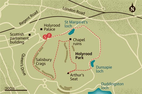
Walk in a nutshell
A thigh-burning climb over rough terrain will reward walkers with rejuvenating views over the water to Fife.
Directions
1. From the car park, cross over and climb the steps ahead.
2. Turn right at the top of the steps and follow the path along the Salisbury Crags.
3. After about 1,250m, before you reach the road, turn left and follow the path up and over the brow of the hill.
4. Head down the broad valley ahead for about 950m, skirting round the boggy ground and eventually joining a metalled path.
5. At the end of the valley, turn right and climb up a steep path towards the chapel.
6. Follow the good path back the way you came but don't drop down the hill.
7. Walk straight ahead and continue on this path into a smaller valley.
8. Head up the right-hand side of the valley, climbing steeply.
9. The path peters out to join the main route to Arthur's Seat. Turn right and head to the top.
10. Head back down on the stepped path, straight down the main route, towards Dunsapie loch.
11. Turn left and walk alongside Dunsapie loch, following the road for about 1,500m to the bottom.
12. Just after a set of barrier gates on the road, take a small path to the left and follow it round St Margaret's loch.
13. Rejoin the main road and walk back to the start.
