
Submarine Detection and Monitoring: Open-Source Tools and Technologies
Part of Submarine Proliferation Resource Collection
Introduction
Nicknamed the “Silent Service,” submarines are considered the most survivable nuclear weapons-delivery platform. They can stay submerged for weeks or even months at a time, and move relatively undetected while on patrol. The United States, Russia, China, North Korea, India, and Pakistan, the United Kingdom, and France have or are developing submarines capable of carrying nuclear weapons systems. An equal number of countries are developing and testing new nuclear-armed submarine-launched ballistic and cruise missiles.1 Such programs have already had a negative impact on stability in several areas of the globe. For example, the United States, its NATO allies, and Russia have ramped up Cold War-esque cat-and-mouse submarine hunts in the North Atlantic.2 Of additional concern is the submarine arms race occurring between India and Pakistan, as well as North Korea’s pursuit of diesel-electric ballistic missile submarine (SSB) capabilities.3
Given the integral deterrence role submarines play in the relationships between nuclear-armed countries, understanding the tools and technologies available for submarine monitoring is strategically important. Advancements in submarine detection have the potential to affect the survivability of submarines as nuclear delivery platforms. Submarine detection and monitoring was traditionally the exclusive domain of highly classified military units specializing in naval anti-submarine warfare (ASW). Military ASW employs technologies such as magnetic anomaly detectors (MAD), which detect tiny disturbances to Earth’s magnetic field caused by metallic submarine hulls, passive and active sonar sensors that use sound propagation to detect objects underwater, as well as radar and high-resolution satellite imagery to detect surfaced submarines. Recent advances in commercial tools and technologies now give open-source researchers some ability to monitor submarine fleets. With commercial satellite imagery, synthetic aperture radar (SAR), hydro-acoustic sensors, and even social media analysis, open-source researchers can better understand the size and composition of countries’ submarine fleets, monitor construction of submarines and submarine bases, and potentially learn about patrol patterns and behaviors.
Commercial Satellite Imagery
Readily accessible high-resolution commercial satellite imagery is one of the most important tools for open-source analysis of submarine activity. Imagery enables researchers to monitor naval shipyards and bases for activity visually, such as those in China and North Korea.
For example, over the years, researchers have used satellite imagery to glean important information about China’s efforts to expand and modernize its fleet of nuclear submarines. In 2007, just as several of China’s new Jin-class (Type 094) SSBs were commissioned, Federation of American Scientists analyst Hans Kristensen began using Google Earth imagery to count the number of operational Jin-class submarines at various bases and shipyards around the country, and later to study the expansion of China’s submarine infrastructure (a network of shipyards, naval bases, underground facilities for missile storage, and submarine demagnetization facilities).4 Imagery of construction at Longpo Naval Base—the home of China’s southern SSBN fleet—revealed interesting clues about China’s SSBN program. For example, Kristensen observed the installation of China’s first submarine demagnetization facility, which strips submarine hulls of residual magnetic fields, pointing to Chinese efforts to deploy less detectable submarines.5
Catherine Dill of the Center for Nonproliferation Studies (CNS) published an article revisiting efforts to count China’s operational Jin-class submarines, but unlike Kristensen, she did so using high frequency satellite imagery from Planet Labs.6 High frequency imagery has revolutionized open-source analysis because it is characterized by a high revisit rate. Often, Planet Labs prioritizes frequent imaging of the same sites (up to twice daily) to enable rapid change detection, as well as comparison of images across multiple sites over the same time periods. Dill captured images of two critical Chinese submarine facilities—the Bohai shipyard and the Longpo Naval Base—on the same day. This enabled her to count Chinese SSBNs more accurately; when using images from different dates, there is a risk of double counting or other errors.
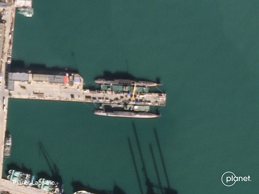
Two Jin-class submarines at the Bohai Shipyard, November 16, 2018. Image courtesy of Catherine Dill and © 2018 Planet Labs, Inc.
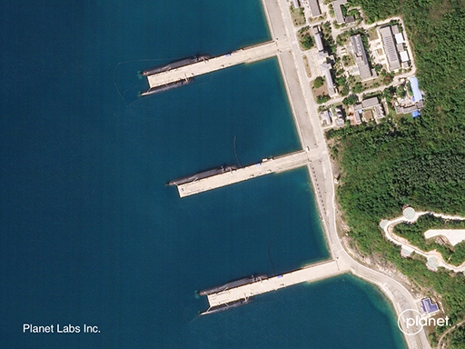
Three Jin-class submarines at Longpo Naval Base, November 16, 2018. Image courtesy of Catherine Dill and © 2018 Planet Labs, Inc.
North Korea maintains one of the largest submarine fleets in the world, estimated at between 64 and 86 submarines. The fleet is comprised primarily of conventionally-armed submarines; however, satellite imagery analysis in recent years has uncovered North Korean efforts to build a class of diesel-electric SSBs and submarine launched ballistic missiles (SLBMs).7 In 2014, open-source analysts spotted North Korea’s first Gorae-class (aka Sinpo-class) ballistic missile submarine at the Sinpo South Naval Shipyard.8 At the same time, analysts watched the development and testing of a solid-fueled SLBM that could potentially arm Gorae-class submarines.9
Synthetic Aperture Radar (SAR)
Synthetic aperture radar (SAR) is a type of space-based imaging that uses radar echoes to create very high resolution 2- or 3-dimensional representations of landscapes, bodies of water, buildings, and other objects.10 SAR sensors can pick up tiny changes to landscapes—such as vehicular and foot traffic—that optical sensors cannot detect. SAR imagery first became commercially available in 1995, however companies did not launch high-resolution SAR sensors until 2007. It’s relative newcomer status in the commercial sector means it is less accessible than optical imagery and often prohibitively expensive.11

SAR images of the nuclear test site at Punggye-ri showing the subsidence of Mount Mantap due to North Korea’s sixth nuclear test. Images source: Airbus Defence and Space, © DLR e.V. 2017 and © Airbus Defence and Space GmbH 2017.
SAR sensors routinely image the ocean for a variety of environmental, scientific, and law enforcement applications. SAR sensors can also detect the wakes of large surface ships. However, SAR’s ability to detect submarine wakes for anti-submarine warfare (ASW) purposes remains inconclusive.
SAR’s ability to enable analysts to detect even tiny changes makes the technology potentially useful for monitoring submarine construction at naval shipyards. For example, SAR imagery could help analysts to monitor North Korea’s Sinpo South Naval Shipyard, and any construction on North Korea’s expanding SSB fleet, by imaging materiel movement. Additionally, SAR sensors could be used to monitor China’s Bohai for frequent updates on the construction of additional Jin-class SSBNs.
Hydroacoustic Monitoring
Submarines must operate quietly in order to evade enemy sensors because water is a highly efficient conductor of sound.12 The main source of noise from a submarine comes from its propulsion system. Thus, the design and quality of the propeller blades matter greatly in ensuring the survivability of a country’s sea-based nuclear deterrent.13 China’s Jin-class SSBN is reportedly very noisy, providing one possible reason why Chinese submarines rarely stray from coastal to deeper waters.14 Countries like the United States and China have built networks of hydroacoustic sensors, which use sonar technology to detect submarines that navigate close to their coastal borders and strategic military locations.15
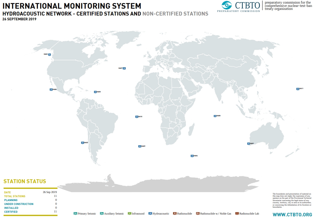
Click map for full-view
Map of hydroacoustic monitoring stations in the CTBTO’s international monitoring system (IMS). Map source: Preparatory Commission for the Comprehensive Nuclear Test Ban Treaty Organization, www.ctbto.org/map.
Traditionally, hydroacoustic monitoring has been the domain of national governments. However, in the civilian and scientific sector, the Comprehensive Nuclear Test Ban Treaty Organization (CTBTO) operates a network of eleven hydroacoustic monitoring stations as part of the International Monitoring System (IMS) for detecting nuclear explosions. The data collected by the CTBTO’s hydroacoustic stations is accessible, by request, for research purposes such as tracking whale migration patterns and developing tsunami warning systems.16 In late 2017, IMS hydroacoustic data was used to locate the last known position of the ARA San Juan, an Argentine submarine that disappeared and sadly sank off the coast of Argentina.17 Open-source researchers could use similar data to isolate the acoustic signatures of submarines and subsequently assess their movements. Analysts could also use this data to analyze SLBM tests by North Korea and other countries developing SLBMs. While open-source researchers have used data from IMS infrasound stations (which track sound waves undetectable to the human ear) to monitor missile and rocket launches on land, hydroacoustic data has not been utilized in a similar fashion.18
Social Media
The rise of social media through platforms such as Facebook, Twitter, Snapchat, and Instagram, as well as crowd-sourcing websites (e.g., www.liveuamap.com) and fitness trackers (e.g., Strava), has made maintaining operational security far more difficult for militaries. In recent years, a number of seemingly harmless Tweets and Instagram pictures have revealed themselves as major security breaches.19 In January 2018, a student at Australian National University discovered that user activity posted on Strava, a fitness app that allows individuals to map their running and biking routes, had unwittingly exposed the locations and perimeters of sensitive military facilities around the world, as well as so-called “patterns of life” of military personnel stations at such facilities.20 Among the facilities profiled was HM Naval Base Clyde in Faslane, Scotland, where the United Kingdom’s nuclear submarine force is berthed. Pictures posted on Twitter show clear heat signatures around the base’s perimeter, indicating either a running route or perimeter patrol.21 Potential “patterns of life” risks with naval personnel include identifying a submariner on Strava and then using their logged exercise locations to map SSBN movements.
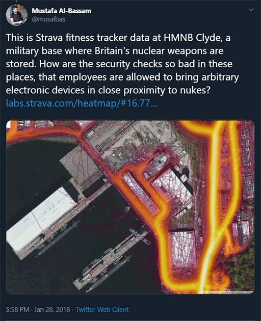
Twitter post of Strava heat map data logged around HM Naval Base Clyde, the home of the U.K.’s SSBN fleet.
“Patterns of life” research isn’t specific to fitness trackers—a simple scan of other social media platforms shows just how much material open-source researchers can access for similar analyses. Naval personnel tend to have active digital lives, much like their civilian counterparts. On Instagram, a simple queries result in images and videos taken by members of various navies while in home or foreign ports. If someone were to tag their location while in full uniform with identifying patches exposed, that could be enough information to identify what ship, surface or submarine, that individual is on, as well as its movements.
Interestingly, searches on Twitter and Instagram reveal a large number of individuals who “sub spot” as a hobby. One individual monitors military vessels, including submarines, that transit the Bosphorus Strait in Turkey.22 Once, a Dutch Naval Commander tweeted a picture of a Russian Krasnodar submarine after it passed his ship in the Bosphorus. Resulting analysis deemed the submarine was likely headed to the port of Tartus, Syria, to aid Russian military operations in the country.23 Other accounts publish images or videos taken by average citizens who just happen to see a giant submarine cruise past them. Still others repost digital media related to submarines published by military accounts.
A photo taken by a Dutch Naval Commander of a Russian Krasnodar submarine as it passes his ship in the Bosphorus Strait in Turkey.
Summary
Commercial satellite imagery, SAR, social media, and hydroacoustic monitoring are just a few of many new tools that have transformed open-source analysis in the nonproliferation field. As the United States, Russia, China, North Korea, India, and Pakistan build up and modernize the sea-based leg of their nuclear arsenals, these tools will remain important to open-source assessments of their programs.
Explore the Collection
Australia Submarine Capabilities
Brazil Submarine Capabilities
Chile Submarine Capabilities
China Submarine Capabilities
France Submarine Capabilities
Germany Submarine Capabilities
Greece Submarine Capabilities
India Submarine Capabilities
Indonesia Submarine Capabilities
Iran Submarine Capabilities
Israel Submarine Capabilities
Italy Submarine Capabilities
Japan Submarine Capabilities
Malaysia Submarine Capabilities
Netherlands Submarine Capabilities
North Korea Submarine Capabilities
Pakistan Submarine Capabilities
Russia Submarine Capabilities
Singapore Submarine Capabilities
South Korea Submarine Capabilities
Sweden Submarine Capabilities
Taiwan Submarine Capabilities
United States Submarine Capabilities
Your are currently on
Submarine Detection and Monitoring: Open-Source Tools and Technologies
Stay Informed
Sign up for our newsletter to get the latest on nuclear and biological threats.
Overview of the Submarine Proliferation Resource Collection
View global trends in sale and acquisition of diesel- and nuclear-powered submarines, information on capabilities, imports and exports.
Indonesia Submarine Capabilities
The Indonesian Navy, also known as Tentar Nasional Indonesia-Angkatan Laut (TNI-AL), operates two classes of submarines:
Australia Submarine Capabilities
A highlight of global trends in the sale and acquisition of diesel- and nuclear-powered submarines by country with capabilities, imports and exports. (CNS)
Glossary
- Nuclear weapon
- Nuclear weapon: A device that releases nuclear energy in an explosive manner as the result of nuclear chain reactions involving fission, or fission and fusion, of atomic nuclei. Such weapons are also sometimes referred to as atomic bombs (a fission-based weapon); or boosted fission weapons (a fission-based weapon deriving a slightly higher yield from a small fusion reaction); or hydrogen bombs/thermonuclear weapons (a weapon deriving a significant portion of its energy from fusion reactions).
- Submarine-launched ballistic missile (SLBM)
- SLBM: A ballistic missile that is carried on and launched from a submarine.
- Cruise missile
- An unmanned self-propelled guided vehicle that sustains flight through aerodynamic lift for most of its flight path. There are subsonic and supersonic cruise missiles currently deployed in conventional and nuclear arsenals, while conventional hypersonic cruise missiles are currently in development. These can be launched from the air, submarines, or the ground. Although they carry smaller payloads, travel at slower speeds, and cover lesser ranges than ballistic missiles, cruise missiles can be programmed to travel along customized flight paths and to evade missile defense systems.
- North Atlantic Treaty Organization (NATO)
- The North Atlantic Treaty Organization is a military alliance that was formed in 1949 to help deter the Soviet Union from attacking Europe. The Alliance is based on the North Atlantic Treaty, which was signed in Washington on 4 April 1949. The treaty originally created an alliance of 10 European and two North American independent states, but today NATO has 28 members who have committed to maintaining and developing their defense capabilities, to consulting on issues of mutual security concern, and to the principle of collective self-defense. NATO is also engaged in out-of-area security operations, most notably in Afghanistan, where Alliance forces operate alongside other non-NATO countries as part of the International Security Assistance Force (ISAF). For additional information, see NATO.
- Deterrence
- The actions of a state or group of states to dissuade a potential adversary from initiating an attack or conflict through the credible threat of retaliation. To be effective, a deterrence strategy should demonstrate to an adversary that the costs of an attack would outweigh any potential gains. See entries for Extended deterrence and nuclear deterrence.
- Nuclear-weapon states (NWS)
- NWS: As defined by Article IX, paragraph 3 of the Treaty on the Non-Proliferation of Nuclear Weapons (NPT), the five states that detonated a nuclear device prior to 1 January 1967 (China, France, the Soviet Union, the United Kingdom, and the United States). Coincidentally, these five states are also permanent members of the UN Security Council. States that acquired and/or tested nuclear weapons subsequently are not internationally recognized as nuclear-weapon states.
- SSBN
- Ship, Submersible, Ballistic, Nuclear: A hull classification for a submarine capable of launching a ballistic missile. The "N", or nuclear, refers to the ship's propulsion system. SSBN's are generally reserved for strategic vessels, as most submarine launched ballistic missiles carry nuclear payloads. A non-strategic vessel carries the designation SSN, or attack submarine.
- Deployment
- The positioning of military forces – conventional and/or nuclear – in conjunction with military planning.
- Submarine-launched ballistic missile (SLBM)
- SLBM: A ballistic missile that is carried on and launched from a submarine.
- Deterrence
- The actions of a state or group of states to dissuade a potential adversary from initiating an attack or conflict through the credible threat of retaliation. To be effective, a deterrence strategy should demonstrate to an adversary that the costs of an attack would outweigh any potential gains. See entries for Extended deterrence and nuclear deterrence.
- Nonproliferation
- Nonproliferation: Measures to prevent the spread of biological, chemical, and/or nuclear weapons and their delivery systems. See entry for Proliferation.
Sources
- Tim Fish, “First Nuclear Deterrence Patrol Marks Major Step for Indian Submarine Force,” USNI News, 12 November 2018, https://news.usni.org; Ankit Panda, “The Risks of Pakistan’s Sea-Based Nuclear Weapons,” The Diplomat, 13 October 2017, thediplomat.com.
- Christopher Woody, “Russia Has ‘Stepped on the Gas’ with Its Submarine Fleet – and NATO is on Alert,” Business Insider, 28 April 2018, www.businessinsider.com.
- Tim Fish, “First Nuclear Deterrence Patrol Marks Major Step for Indian Submarine Force,” USNI News, 12 November 2018, https://news.usni.org; Ankit Panda, “The Risks of Pakistan’s Sea-Based Nuclear Weapons,” The Diplomat, 13 October 2017, https://thediplomat.com.
- Hans M. Kristensen, “New Chinese Ballistic Missile Submarine Spotted,” Federation of American Scientists, 5 July 2007, https://fas.org; Hans M. Kristensen, “Two More Chinese SSBNs Spotted,” Federation of American Scientists, 4 October 2007, https://fas.org; Hans M. Kristensen, “China SSBN Fleet Getting Ready – But for What?”, Federation of American Scientists, 25 April 2014, https://fas.org.
- Hans M. Kristensen, “China SSBN Fleet Getting Ready – But for What?” Federation of American Scientists, 25 April 2014, https://fas.org.
- Catherine Dill, “Counting Type 094 Jin-Class SSBNS with Planet Imagery,” Arms Control Wonk, 21 November 2018, www.armscontrolwonk.com.
- “North Korea Submarine Capabilities,” Nuclear Threat Initiative, 4 October 2018, www.nti.org.
- “North Korea Submarine Capabilities,” Nuclear Threat Initiative, 4 October 2018, www.nti.org.
- “North Korea Submarine Capabilities,” Nuclear Threat Initiative, 4 October 2018, www.nti.org.
- C.R. Jackson and J.R. Apel, “Synthetic Aperture Radar Marine User’s Manuel,” National Oceanic and Atmospheric Administration, www.sarusersmanual.com.
- David Germroth, “Commercial SAR Comes to the U.S. (Finally!),” Apogeo Spatial, Spring 2016, http://apogeospatial.com.
- “Hydroacoustic Monitoring,” CTBTO, www.ctbto.org.
- Kyle Mizokami, “What Makes Submarines So Quiet,” Popular Mechanics, 15 August 2017, www.popularmechanics.com.
- Hans M. Kristensen, “China’s Noisy Nuclear Submarines,” Federation of American Scientists, 21 November 2009, https://fas.org; Jeffrey Lewis, “China’s Noisy New Boomer,” Arms Control Wonk, 24 November 2009, www.armscontrolwonk.com.
- Joseph Trevithick, “China Reveals It Has Two Underwater Listening Devices within Range of Guam,” The Warzone, 23 January 2018, www.thedrive.com.
- CTBTO, “Hydroacoustic Monitoring.”
- “CTBTO Hydroacoustic Data Used to Aid Search for Missing Submarine ARA San Juan,” CTBTO Information Centre, 24 November 2017, www.ctbto.org/press-centre.
- Bharath Gopalaswamy, “Observing Missile Launches Using Infrasound Technology,” Trust and Verify VERTIC Newsletter, Issue 127 (October-December 2009), www.vertic.org.
- Max Seddon, “Does This Soldier’s Instagram Account Prove Russia Is Covertly Operating in Ukraine?” BuzzFeed News, 30 July 2014, www.buzzfeednews.com.
- Jeremy Hsu, “The Strava Heat Map and the End of Secrets,” WIRED, 29 January 2018, www.wired.com.
- Brian Donnelly, “Fear of Security Breach at Faslane from Soliders Using Fitness App,” The Herald, 29 January 2018, www.heraldscotland.com.
- Bosphorus Naval News, https://twitter.com.
- Kramer, Rob, Twitter Post, 5 May 2017, 5:51 AM.