Advertisement
Advertisement

Weather Explainers

Spectacular Undulatus Asperatus Cloud Images Captured in Kentucky, Ohio

By Linda Lam

August 04, 2015

image

Asperatus Clouds

Asperatus clouds observed in Cincinnati, Ohio by Ron Steele on August 3, 2015.
Advertisement

Spectacular images of undulatus asperatus clouds were captured on Monday in Kentucky and southern Ohio and shared on social media.

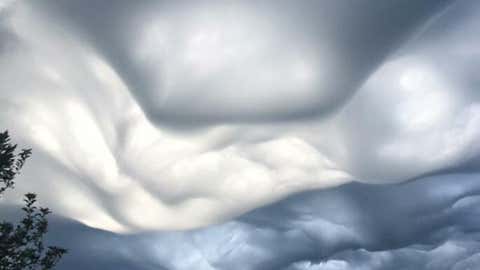
Undulatus means wavy and asperatus translates as agitated or roughed, so the name is Latin for "agitated waves."

(MORE: 10 Amazing Clouds)

image

Asperatus Clouds

Asperatus clouds captured by Johannah McKinney Cheek in Harrodsburg, Kentucky on August 3, 2015.

Undulatus asperatus clouds are a rare formation that was proposed as a new category of cloud in 2009, according to the National Weather Service, and is likely to become the first cloud formation added since 1951 to the International Cloud Atlas of the World Meteorological Organization.

In this case, these incredible images were seen while thunderstorms were in the area early Monday morning.

Advertisement
image

Asperatus Clouds

Asperatus clouds captured in Lawrenceburg, Kentucky on August 3, 2015 via Facebook by Kathy Bickers.

These ominous looking clouds can sometimes be observed ahead of a thunderstorm, after the thunderstorm's gust front has blown through. In other words, ahead of either a single thunderstorm or line of storms, you may first experience a strong gust of wind, which is the gust front. Look skyward (from a safe place in a thunderstorm, that is) and you may see these undulatus asperatus clouds. 

(MORE: Asperatus and Roll Clouds Over Georgia, South Carolina)

What these clouds really depict is turbulent wave motion. According to Graeme Anderson, from the Department of Meteorology at Reading University, winds at cloud level lead to sufficient wind shear to produce the wavy motion. The wavy motion of the air becomes visible in the form of undulations (waves) in the cloud base.

MORE ON WEATHER.COM: Mammatus Clouds (PHOTOS)

These eerie mammatus clouds appeared over a high school graduation ceremony in Pekin, Ill., on May 22, 2011, as part of the tornado outbreak that produced the devastating Joplin tornado the same day. (Credit: iWitness Weather/Candi Carter Kupris)
1/12
These eerie mammatus clouds appeared over a high school graduation ceremony in Pekin, Ill., on May 22, 2011, as part of the tornado outbreak that produced the devastating Joplin tornado the same day. (Credit: iWitness Weather/Candi Carter Kupris)
Advertisement

Weather in your inbox

Your local forecast, plus daily trivia, stunning photos and our meteorologists’ top picks. All in one place, every weekday morning.

By signing up, you're opting in to receive the Morning Brief email newsletter. To manage your data, visit Data Rights. Terms of Use | Privacy Policy

Advertisement

Your Privacy

To personalize your product experience, we collect data from your device. We also may use or disclose to specific data vendors your precise geolocation data to provide the Services. To learn more please refer to our Privacy Policy.

Choose how my information is shared

Arrow Right
Review All Privacy and Ad Settings
Hidden Weather Icon Masks
Hidden Weather Icon Symbols