Shelf Cloud vs. Wall Cloud: What is the Difference
Every spring, severe storms cause some really awesome or perhaps some scary-looking skies, depending on how you view it. The angry-looking sky causes people to take lots of pictures and send them our way, which we greatly appreciate, as long as you are doing it in a safe manner. However, some people miss label a shelf cloud as a wall cloud. In this article, we outline the difference between the two, as there is a major difference.

What is a Shelf Cloud
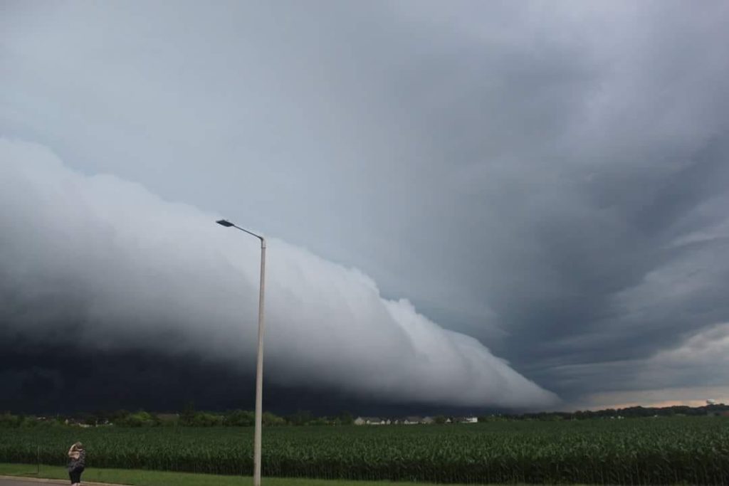
Shelf clouds are often associated with squall lines, and many times they are reported as wall clouds, funnel clouds or rotation. Below is a brief review of what a shelf cloud, wall cloud, and funnel cloud look like. Remember, that the main threat with any squall line is severe damaging winds associated with the shelf cloud, although brief spin-up tornadoes can occur. Oftentimes, these tornadoes are rain-wrapped and short-lived. A shelf cloud will usually be associated with a solid line of storms. The wind will come first with rain following behind it. It may appear to rotate on a horizontal axis.

What is a Wall Cloud
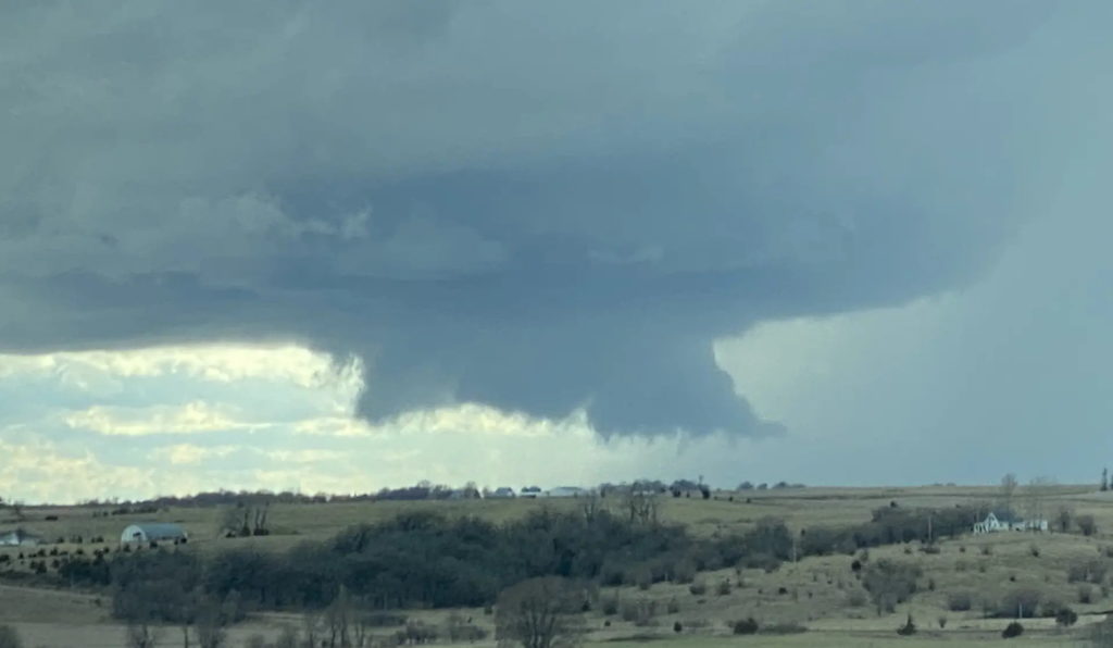
A wall cloud is a large, localized, persistent, and often abrupt lowering of cloud that develops beneath the surrounding base of a cumulonimbus cloud and from which tornadoes sometimes form. It is typically beneath the rain-free base portion of a thunderstorm and indicates the area of the strongest updraft within a storm. Rotating wall clouds are an indication of a mesocyclone in a thunderstorm; most strong tornadoes form from these. Many wall clouds do rotate, however, some do not.
Frequently Asked Questions About Wall Clouds and Shelf Clouds
What is a wall cloud?
A wall cloud is a distinct, often circular lowering of a cloud base that forms beneath a severe thunderstorm. It is typically located in the vicinity of a rotating updraft or mesocyclone. Wall clouds are frequently associated with supercell thunderstorms and can be a visual indication of potential tornado development.
How does a wall cloud form?
A wall cloud forms when warm, moist air rises and encounters colder air aloft. As the warm air rises and condenses, it creates a rotating updraft within the storm. If the conditions are favorable for strong rotation, a wall cloud may develop beneath the updraft region.
What is a shelf cloud?
A shelf cloud is a low, horizontal cloud formation typically associated with the leading edge of a gust front, which is the boundary between advancing cold air from a thunderstorm and warm air ahead of it. Shelf clouds often appear dark and menacing, but they are usually not as dangerous as wall clouds.
Are all wall clouds indicative of tornadoes?
Not all wall clouds produce tornadoes, but they are often closely associated with tornado formation in supercell thunderstorms. However, it is crucial to note that not every wall cloud leads to a tornado. Meteorologists and storm spotters monitor wall clouds for signs of further intensification and rotation, which may suggest an increased risk of tornado development.
How is a shelf cloud different from a wall cloud?
The primary difference between a shelf cloud and a wall cloud lies in their appearance and associated weather patterns. A shelf cloud is a low, horizontal cloud formation found along the leading edge of a thunderstorm’s outflow. It is often smooth and appears wedge-shaped. In contrast, a wall cloud is a vertical cloud formation that appears beneath a severe thunderstorm, showing rotation and the potential for tornado development.
Are shelf clouds dangerous?
Shelf clouds are generally not as dangerous as wall clouds. They are associated with gusty winds and the outflow of cold air from a thunderstorm but do not possess the same tornado potential as wall clouds. However, gust fronts and associated outflow winds can still be strong enough to cause damage, particularly near the leading edge of a thunderstorm.
What precautions should I take if I spot a wall cloud or shelf cloud?
If you observe a wall cloud, take it as a sign that the thunderstorm has the potential to produce a tornado. Seek shelter immediately in a sturdy building or storm shelter. Pay attention to weather updates and warnings from local authorities. Avoid being near windows, and stay away from mobile homes or vehicles.
For shelf clouds, while they are not an immediate tornado threat, be aware that they may bring strong, gusty winds and heavy rainfall. It’s best to stay indoors during the passage of the shelf cloud and refrain from venturing outside until the storm has passed.
Can I predict the formation of wall clouds or shelf clouds?
As an ordinary individual, it may be challenging to predict the exact formation of wall clouds or shelf clouds without access to specialized weather equipment and knowledge. It’s essential to stay informed about weather forecasts and warnings from reputable sources and consider downloading weather apps that provide real-time alerts for severe weather.
How do meteorologists track and monitor wall clouds and shelf clouds?
Meteorologists monitor wall clouds and shelf clouds using a combination of ground-based weather radar, satellite imagery, and reports from trained storm spotters. Doppler radar can detect rotation in storms, while storm spotters in the field provide valuable on-the-ground observations to help meteorologists issue timely warnings to the public.
What are some other cloud formations associated with severe weather?
In addition to wall clouds and shelf clouds, other cloud formations linked to severe weather include:
- Cumulonimbus clouds: Tall, towering clouds with an anvil-shaped top, often associated with thunderstorms.
- Mammatus clouds: Bulbous, pouch-like cloud formations that form beneath thunderstorm anvils, indicating turbulent conditions aloft.
- Supercell clouds: Large, rotating thunderstorms with a well-defined updraft, capable of producing severe weather, including tornadoes.
- Anvil clouds: Flat, spreading cloud formations at high altitudes that form from the upper parts of thunderstorms.
Remember, it’s crucial to stay weather-aware and seek shelter when severe weather threatens. Always prioritize your safety and follow the guidance of local authorities during severe weather events.
Story Image: Adam Walters – Huxley, Iowa