File:Muddus national park topographic map-fr.svg
Jump to navigation
Jump to search

Size of this PNG preview of this SVG file: 489 × 599 pixels. Other resolutions: 196 × 240 pixels | 392 × 480 pixels | 627 × 768 pixels | 836 × 1,024 pixels | 1,672 × 2,048 pixels | 2,000 × 2,450 pixels.
Original file (SVG file, nominally 2,000 × 2,450 pixels, file size: 1.51 MB)
Captions
Captions
Add a one-line explanation of what this file represents
Summary[edit]
| Description |
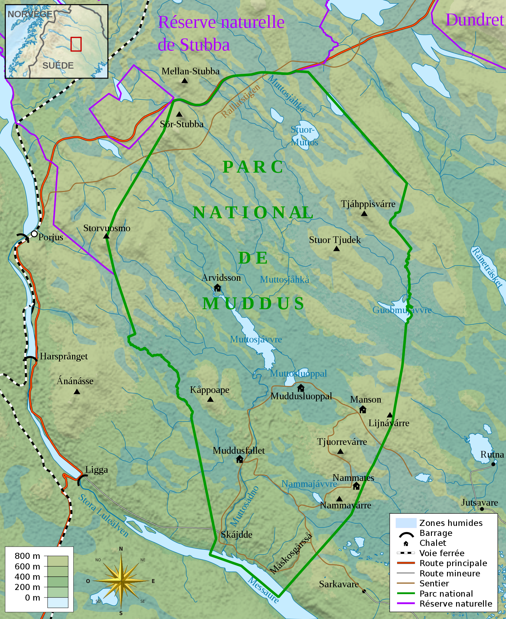
Français : Carte topographique du parc national de Muddus, en Laponie suédoise.
English: Topographic map in French language of Muddus national park, Swedish Lappland
|
| Date | |
| Source |
Création personnelle ;
|
| Author | Mickaël Delcey (Silverkey) |
_(-mini_map).svg)
Licensing[edit]
I, the copyright holder of this work, hereby publish it under the following license:
This file is licensed under the Creative Commons Attribution-Share Alike 3.0 Unported license.
- You are free:
- to share – to copy, distribute and transmit the work
- to remix – to adapt the work
- Under the following conditions:
- attribution – You must give appropriate credit, provide a link to the license, and indicate if changes were made. You may do so in any reasonable manner, but not in any way that suggests the licensor endorses you or your use.
- share alike – If you remix, transform, or build upon the material, you must distribute your contributions under the same or compatible license as the original.
File history
Click on a date/time to view the file as it appeared at that time.
| Date/Time | Thumbnail | Dimensions | User | Comment | |
|---|---|---|---|---|---|
| current | 00:43, 1 January 2017 | | 2,000 × 2,450 (1.51 MB) | Silverkey (talk | contribs) | Change river name (it changes name along its course) + few details |
| 19:03, 26 December 2016 |  | 2,000 × 2,450 (1.5 MB) | Silverkey (talk | contribs) | A few forgotten details (sorry) | |
| 18:54, 26 December 2016 |  | 2,000 × 2,450 (1.5 MB) | Silverkey (talk | contribs) | Use Sami spellings instead of Swedish ones (as is now standard). A few minor corrections. | |
| 11:25, 27 April 2013 |  | 2,000 × 2,450 (1.5 MB) | Silverkey (talk | contribs) | User created page with UploadWizard |
You cannot overwrite this file.
File usage on Commons
There are no pages that use this file.
File usage on other wikis
The following other wikis use this file:
- Usage on cs.wikipedia.org
- Usage on es.wikipedia.org
- Usage on eu.wikipedia.org
- Usage on fr.wikipedia.org
- Usage on gl.wikipedia.org
- Usage on it.wikipedia.org